
Fresh Water at Sea Page Menu: 1 2 3 4 5 6 7 8 9 Next>>
Fresh Water at Sea in the Golden Age of Piracy, Page 3
Getting Fresh Water - Land-Based Location Mapping
This brings us to the maps showing the locations of watering stops given in the period texts. Keep in
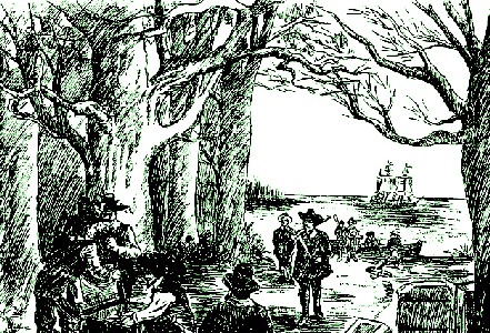
Making Landfall, From Pirates and Piracy, by Oscar Herrmann (1902)
mind that this is not a list of voyage origins and destinations, but a list of stopping points along the way. There are only a few references to the most logical watering places - places where ships started from or where they stopped at for extended periods. As a result, there are few references to places such as Holland, England, Barbados, Jamaica or some of the notable English and Dutch colonies. Instead these maps provide a tapestry of temporary stops where water was gathered along the way.
There are 699 total occurrences of stopping for water in the period accounts used here, resulting in 317 unique locations. These are indicated using numbers on the nine maps which make up this section. Notes are given for each number which provide 1) the modern location name, 2) the location name the author used in square brackets if he gives one (these appear like '[Trimlewas]'), 3) the book/author referenced, 4) the page where the reference can be found in that book and 5) an indication of the certainty of identification for that location in parenthesis when it is uncertain. (This appears as '(prob)' when the location is probably correct and (poss) when it is only possibly correct.)
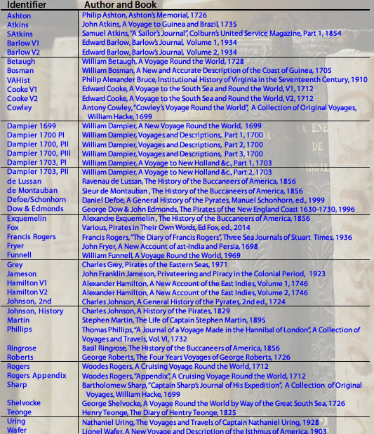
Photo: Benjamin Núñez González - Key to Book Used in Watering Location Notes on Maps
For brevity, the books used here are abbreviated using the author's name and any other relevant information required as shown in the chart at left.
It is sometimes necessary to indicate when a location is uncertain in the notes when there was difficulty translating 17th and 18th century location to a modern area. Many city names in South and Central America and the East Indies are different today than they were in the 1700s. In addition, sailors often spelled location names phonetically, based on location names they heard... or thought they heard. Lacking any other reference, authors sometimes even assigned a name to a place which was used by no one other than them.
In addition to names, some authors provide the latitude for locations. While these are usually close, they are not always exact. (In determining which coastal cities lay along a given latitude, this website proved invaluable.) Many of the books also indicate location by giving the distance it was from another port, again with varying amounts of accuracy. (Using this information is often tricky because it often depends on correctly interpreting a chain of distances between a known, named place and several unknown ones. One incorrectly determined location affects all the distance calculations following it.)
As a result, while some of the locations are fairly easy to determine, others are best guesses determined using whatever information the author has given, including location names, longitude, distances from known locations, the work of modern authors who have identified these places and the position of old location names from maps drawn during or before the period the book was written. (Some of the period books contained maps which were of varying degrees of usefulness based on their accuracy. Many of the other period maps used were found on the David Rumsey Map Collection website.)
Getting Fresh Water - Europe and North Africa Map
The period sailor's books include thirty-nine watering stops taken from fifty-six watering stops mentioned by period authors in Europe and Northern Africa. Because voyage origins are not strongly reflected in this data, this list is relatively small for such a large and important area. A majority of the water references on this map come from books discussing the movements of the Navy and merchants.
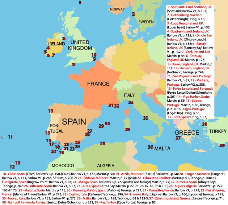 Getting Fresh Water Around the Golden Age of Piracy in Europe and North Africa |
Getting Fresh Water - West Africa Map
The manuscripts contain thirty-five watering locations gathered from one hundred and one watering stop data descriptions in Western Africa. There are only about a third as many stops as there are data points in the period sailing descriptions, making this the most concentrated map of the nine. This is primarily because there three key watering stops along this route which are mentioned by several authors: the Cape of Good Hope (35), St. Helena (32) and the Cape Verde Islands (5-15). Although the Cape Verde Islands are a bit overweighted by George Roberts' repeated mentioning, Santiago (14) and São Nicolau (5) were still popular watering stops in their own right. Several types of voyagers including buccaneers, merchants and pirates comprise the data on this map reflecting this continent's status as an important watering location on a major trade route.
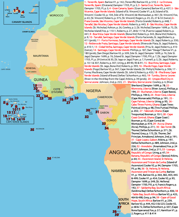 Getting Fresh Water Around the Golden Age of Piracy in West Africa |
Getting Fresh Water - Madagascar and Surrounding Islands Map
| The only area of any note mentioned in reference to stopping for water along the East African coast is at Madagascar and its surrounding islands - the Comoros, Mauritius and Reunion. Twelve locations are mentioned which have been generated from twenty-six data points. As a percentage of the total data, this area contains the most pirate water stops of any map. The rest are mostly merchant vessels. |
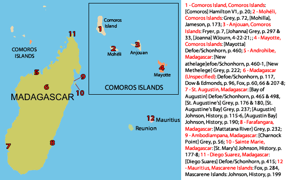 Getting Fresh Water Around the Golden Age of Piracy at Madagascar and Surrounding Islands |
Getting Fresh Water - Middle East and India Map
There are twenty-nine watering locations generated from forty-four mentions of going to shore for refreshment in the Middle East and India. These tend to have been made by pirates and merchants during the golden age of piracy, which should not be surprising. Trade to the East Indies was booming and where there was trade, there were rich prizes for pirates.
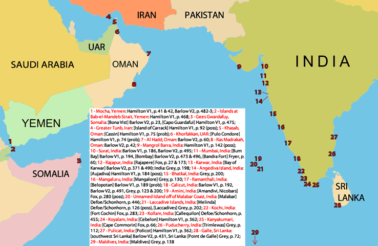 Getting Fresh Water Around the Golden Age of Piracy in the Middle East and India |
Getting Fresh Water - The East Indies Map
Sailors specifically mention stopping for water eighty-two times in the East Indies (not including India which is is the previous map.) These include fifty-two unique locations. The type of traveler stopping here tends to be quite varied, including merchants, explorers, privateers and buccaneers. The privateers and buccaneers often stopped in the East Indies when heading home from the western South American Coast. Buccaneer and explorer William Dampier figures heavily in the makeup of this map which isn't surprising given that between his first circumnavigation and his exploratory voyage to Australia and Indonesia he spent several years here.
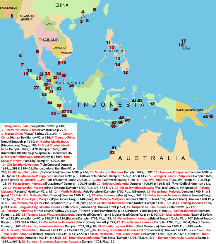 Getting Fresh Water Around the Golden Age of Piracy in the East Indies |
Getting Fresh Water - North America and the Bahamas Map
Only ten watering locations are mentioned in North America and the Bahamas, being generated from twelve data points. Many merchant ships spent several months in North American ports waiting for good weather to carry them back to Europe, which may explain why this map contains the smallest pool of data of all nine maps. This was a long-term destination. There's quite a bit of pirate activity evident in this map.
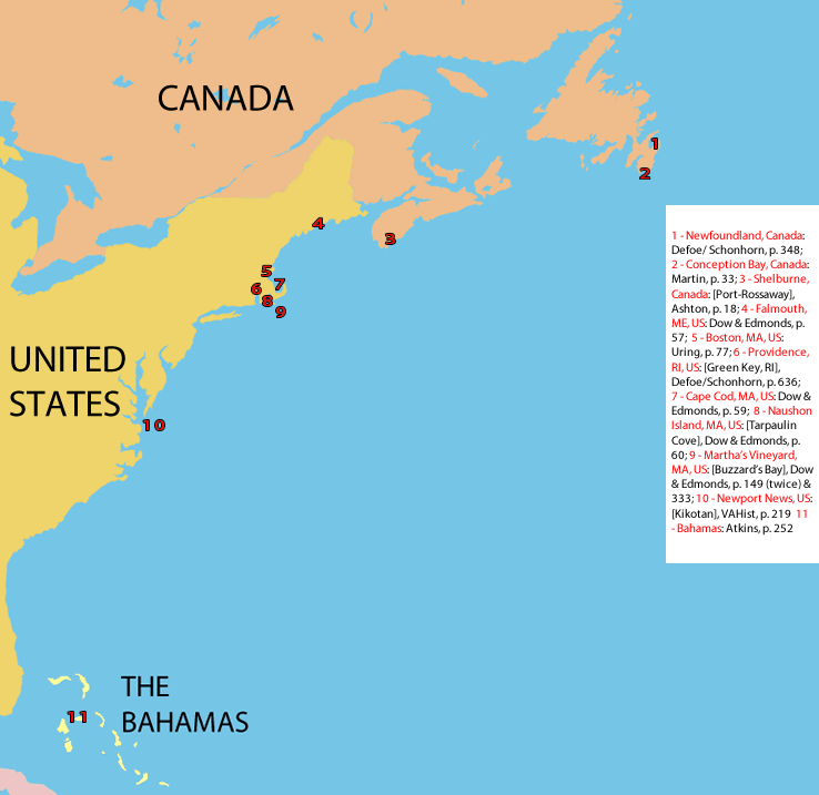 Getting Fresh Water Around the Golden Age of Piracy in North America and the Bahamas |
Getting Fresh Water - Mexico Map
The sea-going books mention stopping for water in Mexico sixty-two times at thirty-four cities. Not surprisingly, this data is entirely composed of information from buccaneering and privateering accounts. The large number of stops in such a relatively concentrated area is at least partially because these accounts tend to give the most detailed information about watering stops.
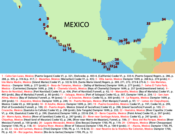 Getting Fresh Water Around the Golden Age of Piracy in the Mexico |
Getting Fresh Water - The Caribbean and Central America Map
The largest number of watering stops is found on the Central American coast and in the Caribbean islands. Eighty different watering locations are recorded here, gathered from one hundred and twenty-nine stops. Many of these stops come from buccaneering and privateering voyages although there are some pirate and merchant stops included as well. Nearly all of the stops along the western coast of Central America are buccaneer-related. The merchant and pirate activity that is mentioned primarily occurs in the Caribbean Sea. Because Jamaica and Barbados ended the first part of many merchants' voyages to the West Indies, they were often long-term destinations resulting in limited mentions by merchants.
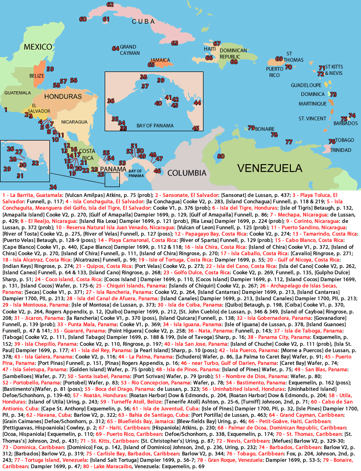 Getting Fresh Water Around the Golden Age of Piracy in Central America and the Caribbean |
Getting Fresh Water - South America Map
At seventy-eight unique watering locations, the South American falls just short of the Central American and Caribbean record of eighty locations. This comes from one hundred and seventy-two watering stops, the largest number on any of the nine maps. Nearly all of the data included here comes from the records of privateers and buccaneers interested in plundering the Spanish coastal towns and ships. Information about where safe water could be found would be useful to other privateers and buccaneers which is probably why it was so complete. In their 1712 accounts, both Edward Cooke and Woodes Rogers refer to the earlier buccaneering accounts when discussing where they chose to stop for water.
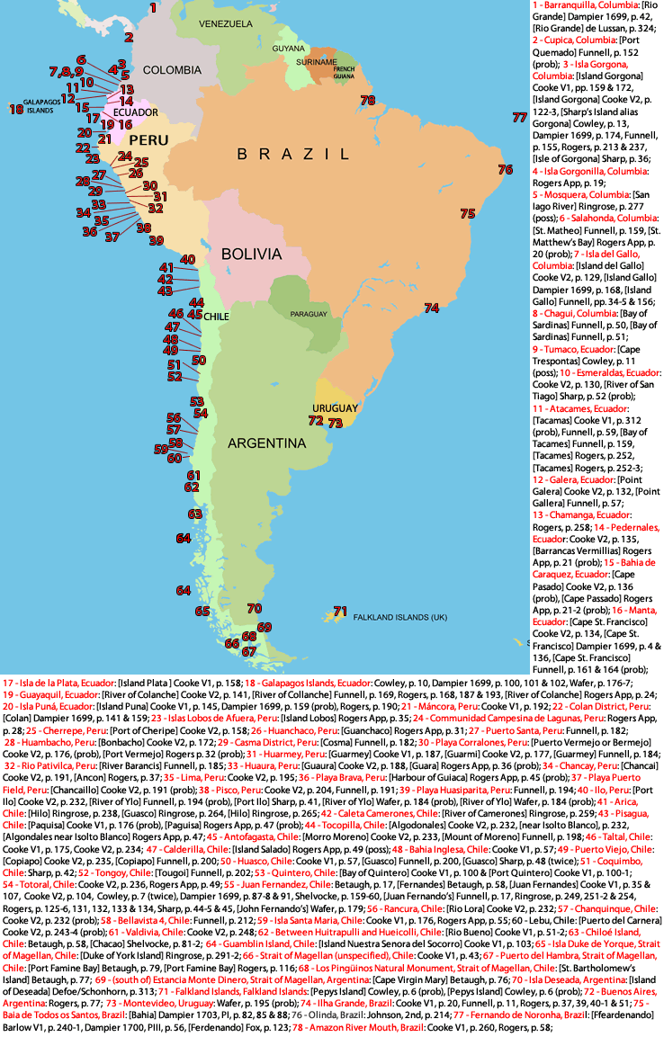 Getting Fresh Water Around the Golden Age of Piracy in South America |
Fresh Water at Sea Page Menu: 1 2 3 4 5 6 7 8 9 Next>>
Main Page • Tools & Procedures • Miscellanea • About the Author • Facebook Page
All original content copyright M. Kehoe • 2003-